


Plumecast Plume Monitoring
Starts atFirst year £3000. Renews for £1,800 annually.
Plumecast is a real time display of areas at risk from airborne plumes and an invaluable decision support tool for dealing with hazardous airborne plumes. A Plumecast system provides instant information on areas affected or at risk.
Product Description
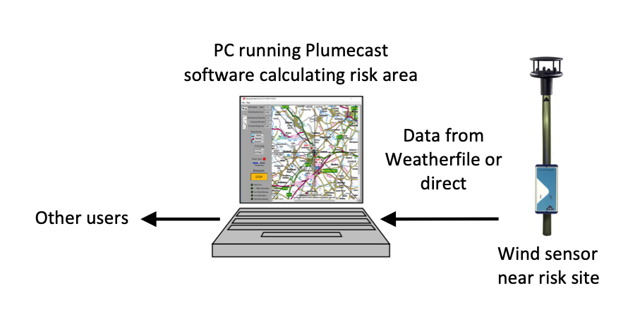
The concept is simple. Plumecast is a combination of software running on a PC and live data. Data can be taken directly or via a Weatherfile site.
The software runs a dispersion model updated every second. It then displays the area at risk from an accidental release and, as an option, in a real emergency can also display the estimated present location of an airborne plume. The use of ultrasonic anemometers allows turbulence characteristics to be measured directly rather than estimated. This makes real time dispersion modelling much more accurate as well as faster.
Intended for top-tier COMAH sites, nuclear facilities and any site used for storage of material that could result in airborne toxic releases, installing Plumecast demonstrates a capability to provide the information required for off-site emergency plans. Plumecast runs continuously, 24 hours a day, 365 days a year so that it can provide important information instantly. Two lines are drawn from the potential pollution source over a map of the local area. These enclose an ‘area at risk’, the area over which airborne pollution might pass in the event of a release. The display also shows range rings showing how far a plume would travel in 10 minutes. These are all updated continuously, using real time sensor data, so that in the event of an accident the area at risk is instantly available. This information can be used in advance of off-site agencies responding. The information, including on-site wind speed and direction, bearings of area at risk lines and 10 minute distances are visible on the screen and can be passed to other agencies involved.
Risk lines are also available in an KML format so the information can be shared with most data communication systems including Resilence direct.
If there is a release at a different location the plume source can be relocated on the local map. This allows a Plumecast system to provide area at risk data for any site where the wind data is representative such as a release from an unexpected site, for example a road traffic accident involving hazardous materials.
In a real incident Plumecast can plot the current location of the plume. This takes the form of a plot overlaid on the local area map.
Plumecast creates an archive in .CSV format. This is compatible with many proprietary spreadsheets including Excel and can be used to generate datasets for training exercises or to analyse past events.
Plumecast is compatible with Windows® Vista, 7, 8 and 10 operating systems.
Please contact sales@r-p-r.co.uk or call +44 (0) 1590 641223 for further information.
Additional information
| Subscription | First year, Renewal |
|---|
| Documentation | |
|---|---|
 |
Plumecast Brochure |
|
Plumecast Overview |
|
Plumecast User Guide |